
Red Panda Population Data Visualization
Red pandas are important due to their taxonomic uniqueness and ecological significance, yet there remains a lack of data and research about the species. This project worked with data provided by the Red Panda Network and reports by the country where the red panda habitat is located.

Background
Fossils of the red panda's ancestors have been unearthed in North America and date as far back as five million years. Today, red pandas are listed as endangered (November 22, 2015) by the IUCN Red List due to habitat loss, human encroachment, poaching, and the effects of climate change.
The red panda is a charismatic mammal with taxonomic uniqueness and ecological significance, yet there remains a lack of data and research about the species.

Endangered and Fragmented
Although the data varies in the red panda range,
researchers cite increases in the human population and the continuing spread of human activity as the main factor behind habitat loss.
Process
First, I started gathering content and data from reports to illustrate the population decline and threats to conservation. Since data was provided by country, specific threats and conservation became segmented by political geography.
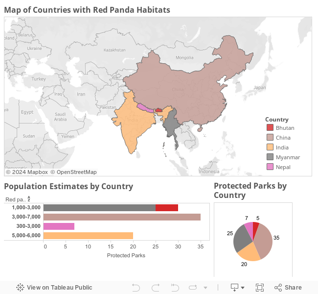
Design
Since the data was central to habitat, the map became the central component. The first iteration was created in Tableau.

Final Visualization
The data visualization project is created with Google Map API, Google Fusion Table, QGIS, Adobe Illustrator, Adobe Photoshop, and Bootstrap and developed with CSS, HTML, JavaScript, and JQuery.
References
Population and Habitat Viability Assessment (PHVA): Nepal (2010) and China (2012).
Human population data - Center for International Earth Science Information Network (CIESIN), Columbia University, and International Centre for Integrated Mountain Development (ICIMOD)
Photos and video - Arkive
Red panda data and spatial range - IUCN Red List.
Illustration and design - Becky Scheel